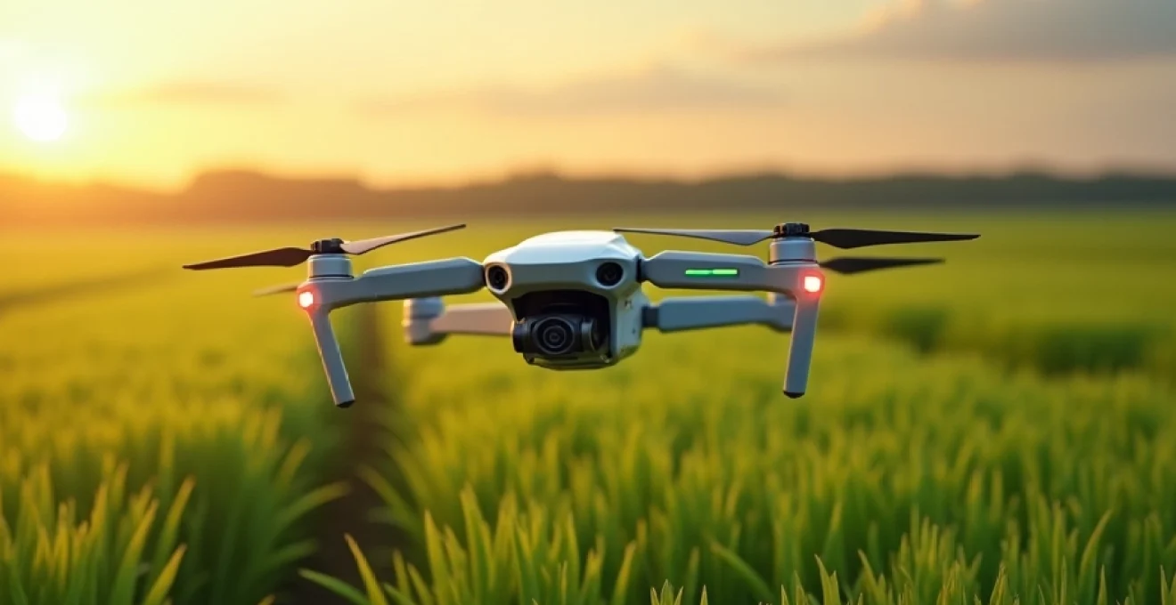
The agricultural sector is experiencing a technological revolution, with drones emerging as powerful tools for enhancing productivity and sustainability. These unmanned aerial vehicles are transforming traditional farming practices, offering unprecedented insights and capabilities. From precision crop monitoring to efficient resource management, drones are reshaping the landscape of modern agriculture.
As farmers face increasing pressure to optimise yields while minimising environmental impact, drone technology provides a versatile solution. These flying devices equipped with advanced sensors and imaging systems enable agriculturists to make data-driven decisions, improve crop health, and streamline operations. The integration of drones in farming practices represents a significant step towards smart agriculture, promising to address many of the challenges facing the industry today.
Precision agriculture: drone technology integration
Precision agriculture leverages cutting-edge technologies to optimise farming practices, and drones are at the forefront of this revolution. By providing high-resolution aerial imagery and real-time data, drones enable farmers to make informed decisions about crop management, resource allocation, and yield prediction. This level of precision was previously unattainable with traditional farming methods.
The integration of drone technology in agriculture goes beyond simple aerial photography. Modern agricultural drones are equipped with sophisticated sensors, GPS systems, and data processing capabilities. These features allow for detailed mapping of fields, identification of problem areas, and even automated spraying of crops. The result is a more efficient, targeted approach to farming that can significantly reduce waste and increase productivity.
One of the key advantages of using drones in precision agriculture is the ability to collect data at a granular level. Farmers can now monitor individual plants within a field, rather than relying on broad assessments of entire crop areas. This detailed information allows for micro-management of agricultural resources , ensuring that each plant receives the optimal amount of water, nutrients, and pest control measures.
Drone technology is revolutionising the way we approach farming, providing unprecedented levels of insight and control over agricultural processes.
Multispectral and thermal imaging for crop health analysis
One of the most powerful applications of drones in agriculture is their ability to capture multispectral and thermal images of crops. These advanced imaging techniques provide farmers with invaluable information about plant health, stress levels, and potential issues that may not be visible to the naked eye.
NDVI mapping with DJI phantom 4 multispectral
The DJI Phantom 4 Multispectral is a popular drone model for agricultural use, specifically designed for Normalized Difference Vegetation Index (NDVI) mapping. NDVI is a crucial indicator of plant health and vigour, calculated using the reflection of near-infrared and red light from vegetation. By analysing NDVI maps, farmers can identify areas of crop stress, nutrient deficiencies, or pest infestations before they become visible problems.
NDVI mapping with the Phantom 4 Multispectral allows for:
- Early detection of crop health issues
- Precise application of fertilisers and pesticides
- Monitoring of crop growth stages
- Assessment of drought stress and irrigation needs
Thermal stress detection using FLIR vue pro R
Thermal imaging adds another dimension to crop health analysis. The FLIR Vue Pro R thermal camera, when mounted on a drone, can detect temperature variations across a field. This capability is particularly useful for identifying water stress, as plants under water stress tend to have higher surface temperatures than well-watered plants.
Thermal imaging can help farmers:
- Optimise irrigation schedules
- Detect drainage issues in fields
- Identify areas of heat stress in crops
- Monitor the effectiveness of irrigation systems
Chlorophyll content assessment via RedEdge-MX
The RedEdge-MX sensor is a sophisticated multispectral camera that can be integrated with various drone platforms. It provides detailed information about chlorophyll content in plants, which is a key indicator of crop health and potential yield. By measuring light reflectance across multiple spectral bands, the RedEdge-MX enables farmers to assess crop vitality with unprecedented accuracy.
Benefits of using the RedEdge-MX for chlorophyll assessment include:
- Early detection of nutrient deficiencies
- Monitoring of crop maturity and harvest timing
- Identification of variations in crop health across fields
- Support for variable rate application of fertilisers
Data processing with Pix4Dfields software
Collecting multispectral and thermal data is only part of the equation. To derive actionable insights, farmers need powerful software tools to process and analyse this data. Pix4Dfields is a leading software solution designed specifically for agricultural drone mapping and analysis. It allows users to transform raw drone imagery into valuable agricultural intelligence.
Key features of Pix4Dfields include:
- Rapid processing of multispectral images
- Generation of precise orthomosaic maps
- Creation of zoning maps for variable rate applications
- Comparison of crop health across different time periods
- Export of data for integration with farm management systems
Drone-based precision spraying and seeding
Beyond imaging and data collection, drones are increasingly being used for direct agricultural interventions such as spraying and seeding. This application of drone technology offers significant advantages in terms of precision, efficiency, and reduced environmental impact compared to traditional methods.
DJI agras T30 for variable rate application
The DJI Agras T30 is a high-capacity agricultural drone designed for precision spraying and spreading. With a 30-litre spray tank and the ability to cover up to 40 acres per hour, it represents a significant advancement in drone-based crop management. The T30 uses real-time kinematic (RTK) positioning for centimetre-level accuracy, ensuring precise application of pesticides, herbicides, or fertilisers.
Key features of the Agras T30 include:
- Variable rate application based on pre-mapped field data
- Obstacle avoidance technology for safer operation
- Automated flight planning for efficient coverage
- Integration with farm management software for data-driven decision making
Yamaha RMAX for hillside vineyard management
The Yamaha RMAX is a specialised agricultural drone that has found particular success in vineyard management, especially in challenging terrains such as hillsides. Its robust design and powerful rotors allow it to navigate steep slopes and uneven terrain that would be difficult or dangerous for ground-based equipment.
Benefits of using the RMAX in vineyard management include:
- Precise application of fungicides and other treatments
- Reduced soil compaction compared to traditional machinery
- Ability to treat areas inaccessible to ground vehicles
- Lower environmental impact due to targeted application
XAG P40 agricultural drone for rice paddy seeding
The XAG P40 is an innovative drone system that has been adapted for seeding applications, particularly in rice paddies. This drone can distribute seeds evenly across flooded fields, a task that is traditionally labour-intensive and time-consuming. The P40’s precision seeding capabilities can lead to more uniform crop growth and potentially higher yields.
Advantages of using the XAG P40 for rice seeding include:
- Reduced labour requirements and costs
- More uniform seed distribution compared to manual broadcasting
- Ability to seed in conditions that may be unsafe for human workers
- Potential for increased crop yields due to optimal seed spacing
Ai-powered crop yield prediction and harvest planning
The integration of artificial intelligence (AI) with drone technology is pushing the boundaries of what’s possible in agricultural planning and management. AI algorithms can analyse vast amounts of drone-collected data to provide insights and predictions that were previously unattainable.
Machine learning algorithms for yield estimation
Machine learning algorithms are being developed to analyse multispectral imagery and other data collected by drones to estimate crop yields with increasing accuracy. These algorithms can identify patterns and correlations in the data that may not be apparent to human observers, leading to more precise yield predictions.
Benefits of AI-powered yield estimation include:
- More accurate crop yield forecasts
- Improved planning for harvest logistics and storage
- Early identification of areas with potential yield issues
- Support for financial planning and market strategies
Integration with john deere operations center
The John Deere Operations Center is a comprehensive farm management platform that can integrate data from various sources, including drones. By combining drone imagery with other farm data, such as soil samples and historical yield information, farmers can gain a more complete picture of their operations and make more informed decisions.
Key features of the John Deere Operations Center include:
- Centralised data management for all farm operations
- Integration of drone imagery with other farm data
- Generation of prescription maps for variable rate applications
- Collaboration tools for sharing data with agronomists and advisors
Sentera FieldAgent for Real-Time analytics
Sentera FieldAgent is a powerful software platform that provides real-time analytics from drone-collected data. It offers farmers immediate insights into crop health, stand count, and other critical metrics, allowing for rapid decision-making and intervention when issues are detected.
Advantages of using Sentera FieldAgent include:
- Real-time crop health monitoring and alerts
- Automated plant population counts
- Integration with popular farm management software
- Cloud-based data storage and sharing capabilities
Regulatory framework and operational limitations
While the potential of drone technology in agriculture is immense, its use is subject to various regulations and operational limitations. Understanding and complying with these regulations is crucial for farmers and agricultural businesses looking to integrate drones into their operations.
CAA drone licensing requirements for UK farmers
In the United Kingdom, the Civil Aviation Authority (CAA) oversees the use of drones, including those used for agricultural purposes. Farmers and drone operators must comply with specific licensing requirements to legally operate drones for commercial agricultural use.
Key requirements include:
- Obtaining an Operator ID for the organisation using the drone
- Securing a Flyer ID for individual drone pilots
- Registering drones weighing more than 250g
- Completing a theory test for drone operation
- Adhering to flight restrictions and privacy regulations
EU commission regulation 2019/947 compliance
For farmers operating within the European Union, compliance with EU Commission Regulation 2019/947 is essential. This regulation establishes a comprehensive framework for the operation of unmanned aircraft systems, including those used in agriculture.
Key aspects of the regulation include:
- Classification of drone operations into open, specific, and certified categories
- Requirements for pilot competency and training
- Operational limitations based on drone weight and capabilities
- Rules for flying in various types of airspace
Weather-related flight restrictions and safety protocols
Weather conditions play a crucial role in drone operations, particularly in agricultural settings. Operators must be aware of and adhere to weather-related flight restrictions to ensure safe and effective drone use.
Important considerations include:
- Wind speed limitations for different drone models
- Visibility requirements for safe operation
- Temperature ranges for optimal battery and sensor performance
- Protocols for avoiding flight during adverse weather conditions
Safety should always be the top priority when operating drones in agricultural settings. Adherence to regulations and weather-related restrictions is essential for responsible drone use.
Economic impact and ROI analysis of agricultural drones
The adoption of drone technology in agriculture represents a significant investment for farmers and agribusinesses. Understanding the economic impact and potential return on investment (ROI) is crucial for making informed decisions about incorporating drones into farming operations.
Several factors contribute to the economic benefits of agricultural drones:
- Reduced labour costs through automation of certain tasks
- Improved crop yields through more precise management
- Decreased input costs due to targeted application of fertilisers and pesticides
- Early detection of crop issues, potentially saving entire harvests
- Enhanced decision-making capabilities leading to overall operational efficiencies
However, the initial investment in drone technology can be substantial. Costs include:
- Purchase of drone hardware and associated sensors
- Software licenses for data processing and analysis
- Training for drone operators and data analysts
- Ongoing maintenance and potential upgrades
To calculate the ROI of agricultural drones, farmers must consider both the direct cost savings and the potential for increased revenue. For example, a study by PwC estimated that the market for drone-powered solutions in agriculture could reach $32.4 billion . This figure suggests significant potential for cost savings and productivity gains across the industry.
Factors affecting ROI can vary depending on farm size, crop type, and specific applications. Larger farms may see faster returns due to economies of scale, while smaller operations might benefit from shared drone services or cooperatives to spread costs.
| Farm Size (hectares) | Estimated Annual Savings | Typical ROI Period |
|---|---|---|
| 0-50 | £500 – £2,000 | 2-3 years |
| 51-200 | £2,000 – £5,000 | 1-2 years |
| 201+ | £5,000+ | 6 months – 1 year |
It’s important to note that these figures are estimates and can vary significantly based on individual circumstances. Farmers should conduct thorough analyses of their specific situations, potentially with the help of agricultural economists or drone service providers, to determine the likely ROI for their operations.
As drone technology continues to evolve and become more accessible, the economic benefits are likely to increase. Innovations in battery life, sensor technology, and AI-driven analysis are expected to further enhance the value proposition of agricultural drones in the coming years.
In conclusion, the integration of drone technology in agriculture represents a significant advancement in farming practices. From precision monitoring and targeted interventions to AI-powered analytics and yield predictions, drones are reshaping how farmers approach crop management. While regulatory compliance and initial investments present challenges, the potential for improved efficiency, sustainability, and profitability makes drones an increasingly attractive option for forward-thinking agricultural operations. As the technology continues to evolve, it’s clear that drones will play an increasingly important role in
shaping how farmers approach crop management. As the technology continues to evolve, it’s clear that drones will play an increasingly important role in the future of sustainable and efficient agriculture.
The economic benefits of agricultural drones are becoming increasingly evident as more farmers adopt this technology. While the initial investment can be significant, many farmers are finding that the long-term benefits outweigh the costs. Let’s explore some key factors that contribute to the positive ROI of agricultural drones:
- Increased crop yields through more precise management of inputs
- Reduction in chemical usage due to targeted application
- Labour cost savings from automated monitoring and spraying
- Early detection of crop stress, pests, and diseases
- Improved water management and irrigation efficiency
A study by the Association for Unmanned Vehicle Systems International (AUVSI) projected that the integration of drones in agriculture could contribute to the creation of more than 100,000 jobs and generate an economic impact of $82 billion by 2025. This highlights the significant potential for growth and economic benefits in the agricultural drone sector.
When considering the ROI of agricultural drones, it’s important to factor in both direct cost savings and potential revenue increases. For example, a farmer using drones for precision spraying might see a 20-30% reduction in pesticide use, leading to significant cost savings. Additionally, the ability to identify and address crop issues early can prevent yield losses, potentially increasing revenue by 10% or more.
The ROI timeline for agricultural drones can vary depending on factors such as farm size, crop type, and specific applications. However, many farmers report seeing a positive return within 1-2 growing seasons. As drone technology continues to advance and become more affordable, we can expect to see even faster ROI timelines in the future.
The key to maximizing ROI with agricultural drones is to integrate them into a comprehensive precision farming strategy, leveraging data analytics and machine learning to drive informed decision-making.
As we look to the future, the economic impact of agricultural drones is likely to grow even further. Advancements in artificial intelligence, machine learning, and sensor technology will continue to enhance the capabilities of these systems, opening up new possibilities for efficiency and productivity in farming. The integration of drone data with other precision agriculture tools and farm management systems will create a more holistic approach to agricultural decision-making, further driving ROI.
In conclusion, while the adoption of drone technology in agriculture requires careful consideration and initial investment, the potential for significant economic benefits is clear. As the technology continues to evolve and become more accessible, we can expect to see drones playing an increasingly central role in modern farming practices, contributing to more sustainable, efficient, and profitable agricultural operations worldwide.